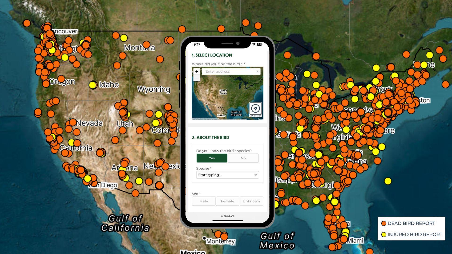
dBird is an online crowd-sourcing tool that collects data on when and where collisions occur, inspiring bird-safe actions across the country. Graphic: dBird.org
Carol Peace Robins, Publications Committee | May 5, 2025
Birds can't see glass—but Darren Klein saw a way to turn this invisible threat into visible data. Back in 2014, while juggling an internship with NYC Bird Alliance (then NYC Audubon) by day with graduate school classes at the New School by night, Darren created dBird.
"It was a fortuitous set of circumstances—my last semester in graduate school, taking a class about building interactive mapping tools,” Darren explains. “I kept seeing people call NYC Bird Alliance about dead and injured birds they'd found. My time interning showed me firsthand there was significant public interest in collisions and that the information was valuable, but there wasn’t anything we could do with it. The maps and the collisions... it just clicked, and dBird became my final project.”
And what a final class project it was! dBird quickly revealed its potential to NYC Bird Alliance as a way to engage a wider audience in the issue of bird-building collisions. By offering a straightforward method for individuals to report their observations, the tool democratizes data collection and fosters a sense of community involvement.
"From the beginning, the core design principle I have tried to adhere to with dBird (which has been consistently supported by NYC Bird Alliance staff throughout dBird's existence) is to make it as quick and easy to use as possible,” Darren offers. “In this way, we hoped to engage a wider audience and collect as much data as possible."
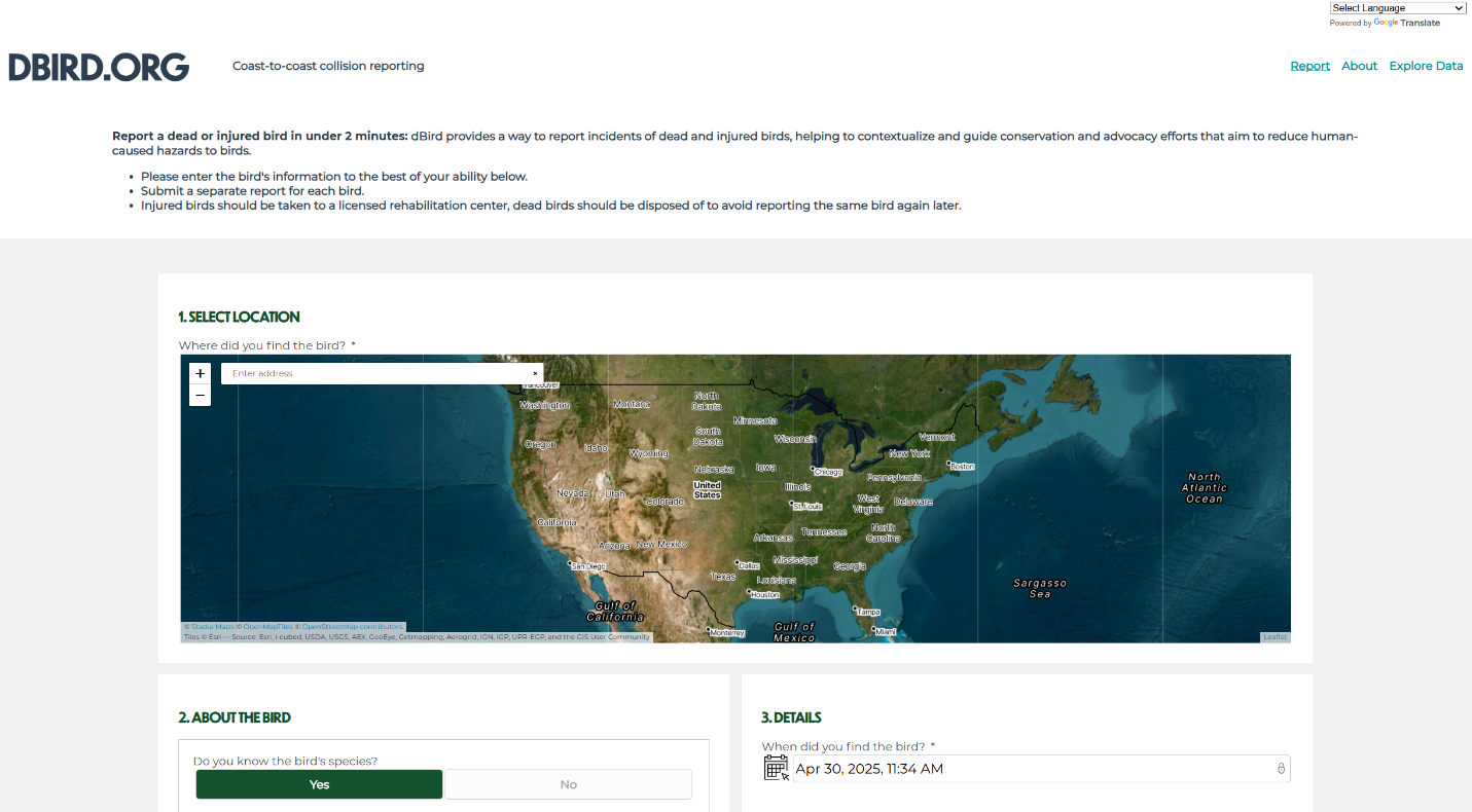
Anyone, from concerned New Yorkers to conservation scientists, could now provide useful data about casualties to NYC Bird Alliance in minutes. You just go to dBird.org on your smartphone and note the bird’s species, age, and sex if possible; indicate the time of day and its location (using a simple press of a button to capture GPS coordinates automatically on smartphones); and note the cause of the accident—almost always, a building collision. Don’t know what type of bird you found? Just snap a photo and upload it quickly for researchers to identify.
While the information gathered may not adhere to the strict scientific protocols of the organization’s nearly three-decade-long Project Safe Flight collision monitoring, reports have informed and augmented this community science research. For instance, after receiving a large number of reports near the City College of New York in 2021, NYC Bird Alliance’s Senior Manager of Community Science and Collision Reduction Katherine Chen added a new “East Harlem” monitoring route to investigate the cause of these collisions.
“dBird is a fantastic way for people concerned about bird collisions to feel empowered to do something to help,” says Katherine. “We don’t have the capacity to assign the hundreds of thousands of volunteers that would be required to monitor all one-million-plus buildings in NYC, so it is important we have this accessible tool that allows anyone to help in our monitoring efforts and provide important data to inform our research.”
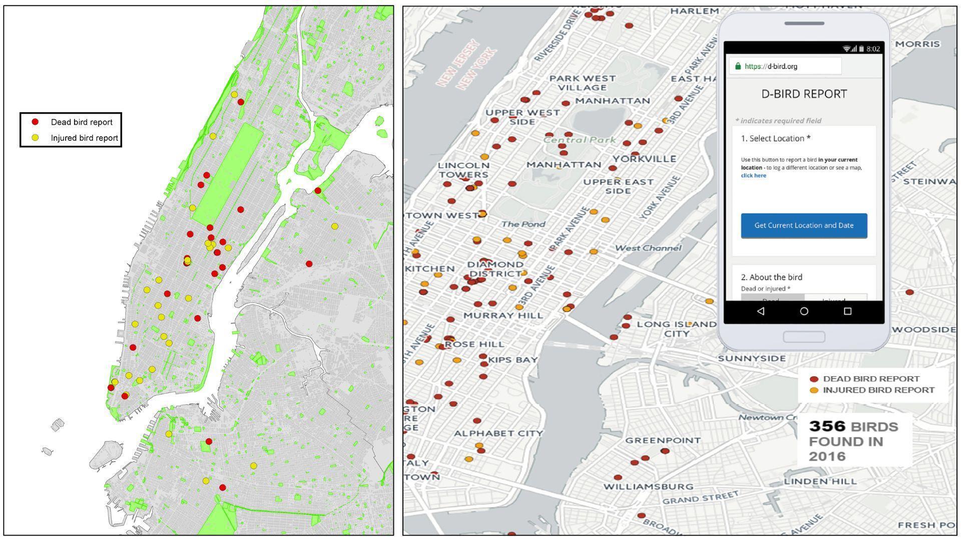
Just as important, dBird has helped fuel NYC Bird Alliance’s advocacy work. Crucially, dBird makes an often-invisible problem visible. All dBird reports show up in real-time on an embeddable map displayed on NYC Bird Alliance’s website, prompting conversations and raising awareness among people who might otherwise be unaware of the dangers birds face in urban environments. Many people have noted how they came to learn about collisions from finding the map, whether through Google searches or seeing the map embedded on other organization’s sites.
“dBird’s superpower lies in its ability to transform raw data into something anyone can view and quickly understand,” says Andrew Maas, director of communications and marketing. “The map makes it incredibly easy to see the extent of the problem, and its accessibility has had a real impact. For instance, after the New York Post discovered the map last fall, it turned into a major story that really raised awareness of this critical issue throughout the City.”
dBird Spreads Its Wings
While initially conceived as a NYC-specific reporting tool, people across the country—even across the globe as far as China—were finding the tool and using it to report collisions. It was not long before a few other conservation organizations in other parts of the country started to adopt the tool, most notably Birds Connect Seattle, to aid collision monitoring programs.
“It’s so helpful for identifying patterns in bird mortality that we can show to architects and building managers to start conversations about bird-safe solutions,” says Birds Connect Seattle’s Josh Morris. Mostly, as he poignantly puts it, “I love the way it allows a dead bird to tell its story.”
A major Seattle success: the Seattle Asian Art Museum. Its recent expansion included expansive glass windows, resulting in a large increase in bird collisions. Josh and volunteers documented museum collisions and presented the evidence to building managers. Consequently, the museum has site-tested four collision deterrent options. A full treatment is expected in the summer of 2025.
NYC Bird Alliance and Birds Connect Seattle formalized a partnership in 2020, working together to expand and improve dBird to allow easier adoption by other organizations, which were increasingly asking to use the tool. Birds Connect Seattle’s Josh Morris, now Urban Conservation Manager for the organization, helped procure funds needed for the refresh, resulting in a generous donation by Seattle philanthropists and bird enthusiasts Jim and Birte Falconer. Darren, who had since left NYC Bird Alliance to work in software development, teamed up with his former New School teacher and software developer Eric Brelsford to design and create the high-tech transformation. In its latest iteration, dBird addressed key requests from conservation organizations around the U.S. by incorporating a full North American species list and a field for noting causes of death or injury besides collisions. These user-centric updates, along with a simplified backend and onboarding process, streamlined the platform for national use. Consequently, over 100 conservation groups have now embraced dBird, actively documenting bird injury and mortality across their respective geographic areas.
Among the many organizations now utilizing dBird is Birds Georgia, where Senior Direct of Programs Adam Betuel recalls starting at the organization over nine years ago and learning in horror that trash collectors in the downtown Atlanta area “just vacuumed up all the dead birds.”
Data collection of casualties, particularly on dBird, became increasingly important to Adam. Recognizing this potential, Adam found fertile ground for dBird's growth at Georgia Tech. Enthusiastic students, including Amanda Junusz of a school birding club called Bird Watchers, became avid spokespeople, often working with Adam. When plans were being developed for the new campus Kendeda Building, Adam contacted the manager to advocate for bird safety. It became one of the first Atlanta buildings to install bird-safe windows. Another was the Trees Atlanta Treehouse, a small campus office building newly constructed with bird-safe glass.
Birds Georgia’s Coastal Conservation Coordinator Sarah Manning reports that four buildings have recently been retrofitted on the coast. She, too, is a big promoter of dBird and proud of the work it helps to accomplish. The most recent is the Camden County High School Fine Arts Building, a largely glass wing of the school that birds couldn’t resist. Volunteers from Camden County Audubon and students and staff from the school spent three days applying bird-safe markings to the glass in February 2025. “It’s too early for definitive results,” says Sarah. “We waited for spring migration to begin monitoring and will continue throughout the coming year.”
In 2024, dBird saw a record number of reports, with over 6,500 incidents logged by dBird users across 47 states. NYC Bird Alliance is proud of the ever-growing interest in dBird and bird-safe buildings. Recent developments, such as the integration of a translation feature, further support this expansion. It’s also important to note that dBird is part of a larger ecosystem of bird mortality reporting tools, including iNaturalist and Global Collision Mapper, all contributing vital data to conservation efforts. Hopefully, bird safety will one day become front and center of all new construction plans across the world.
Meanwhile, Happy Birthday, dBird! Keep up the great work.
Help Scientists Research Bird Collisions If you see a dead or injured bird, please report it. The data helps researchers across the country study the cause of bird mortality and ways to protect birds. If it is injured, take it to a rehabber.
Help Pass Bird-safe Legislation NYC Bird Alliance’s advocacy team works with City and State legislators to make New York City a safer and more sustainable place for birds and people. Learn about our current advocacy priorities and how you can help.